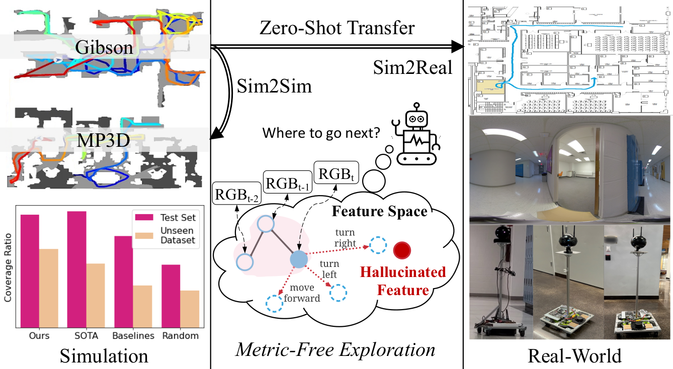
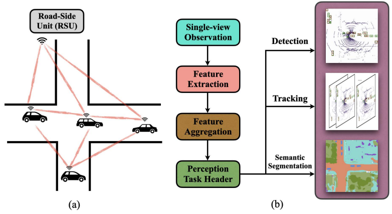
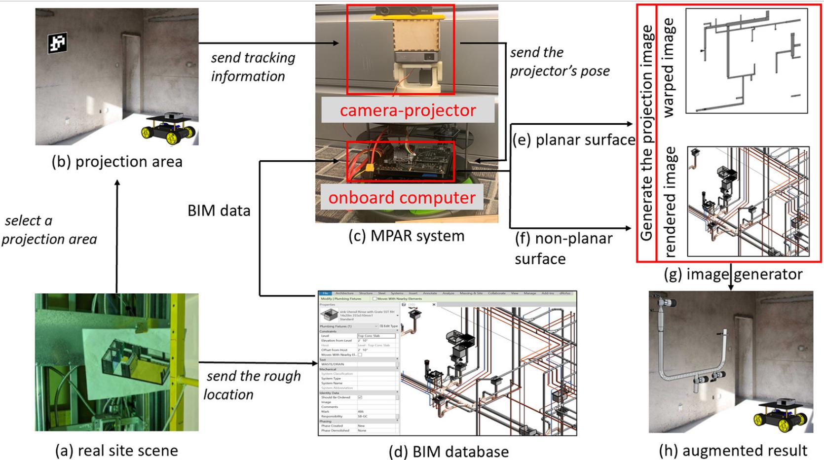
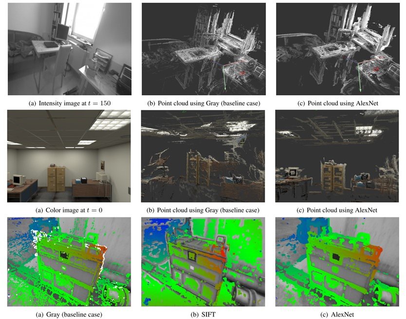
Xinhao Liu
Jiaqi Li
Youming Deng
Ruxin Chen
Yingjia Zhang
Yifei Ma
Li Guo
Yiming Li
Jing Zhang
Chen Feng
Heyang Yu
Yinan Han
Xiangyu Zhang
Baiqiao Yin
Bowen Chang
Xiangyu Han
Marco Pavone
Saining Xie
Jisang Han
Sunghwan Hong
Jaewoo Jung
Wooseok Jang
Honggyu An
Qianqian Wang
Seungryong Kim
Sihang Li
Zeyu Jiang
Grace Chen
Chenyang Xu
Siqi (Kevin) Tan
Xue Wang
Irving Fang
Kristof Zyskowski
Shannon P. McPherron
Radu Iovita
Zhen Jia
Boyi Li
Yan Wang
Boris Ivanovic
Yurong You
Lingjie Liu
Yue Wang
Chao Chen
Nobel Dang
Juexiao Zhang
Wenkai Sun
Pengfei Zheng
Xuhang He
Yimeng Ye
Taarun Srinivas
Beichen Wang*
Juexiao Zhang*
Shuwen Dong
Taiyi Pan
Junyang He
Zegang Cheng (Hooley)
Li Ding
Ruoyu Wang
Jintong Li
Yicheng Jiang
Niranjan Sujay
Zhicheng Yang
John Abanes
Gao Zhu
Haorui Song
Xinran Tang
Zehong Wang
Zhiding Yu
Zan Gojcic
Jose M. Alvarez
Kairui Shi
Xujin He
Yifan Wang
Hanwen Zhao
Hung-Jui Huang
Wenzhen Yuan
Zhiheng Li
Nuo Chen
Moonjun Gong
Zonglin Lyu
Peili Jiang
Yuzhong Chen
Jianghan Zhang
Qiushi Zhang
Jiali Xu
Xibo He
Weibo Gao
Hao Su
Mingxuan Lu
Diwei Sheng
Anbang Yang
John-Ross Rizzo
Hao Wu
Akshat Kaushik
Alice Rodriguez
Zhuo Zheng
Suozhi Huang
Qi Fang
Haoyu Xie
Hang Zhao
Kenan Li
Zijun Wang
Tao Jiang
Fisher Yu
Jiamu Bai
Siheng Chen
Felix Juefei-Xu
Sanbao Su
Songyang Han
Zhili Zhang
Caiwen Ding
Fei Miao
Yuhang He
Rushi Bhavesh Shah
Uksang Yoo
Alvaro Altamirano
Chris Choy
Chaowei Xiao
Sanja Fidler
Anima Anandkumar
Wenyu Han
Haoran Wu
Eisuke Hirota
Alexander Gao
Lerrel Pinto
Ludovic Righetti
Sihong He
Yiming Li*
Dekun Ma
Xuchu Xu
Ziyan An
Zixun Wang
Yiqi Zhong
Siyuan Xiang
Yanfei Xue
Yaoqing Yang
Ziang Cao*
Andrew Liang
Benjamin Liang
Luoyao Chen
Jeremy Shen
Erdong Xiao
Yuchen Liu
Yang Huang
Shunli Ren
Pengxiang Wu
Wenjun Zhang
Yuxiang Chai
Xinru Li
Jianzhe Lin
Claudio Silva
Uljad Berdica
Yuewei Fu
Emmanouil Angelidis
Ziteng Wang
Armand Jordana
Dong Liu
Congcong Wen
Baoan Liu
Carlos Vallespi-Gonzalez
Carl Wellington
Lichao Xu
Vineet R Kamat
Carol C Menassa
Chenhui Liu
Rongmei Lin
Weiyang Liu
Zhen Liu
James M Rehg
Li Xiong
Le Song
Shiheng Wang
Songyu Du
Abhinav Kumar
Tim K Marks
Wenxuan Mou
Ye Wang
Michael Jones
Anoop Cherian
Toshiaki Koike-Akino
Xiaoming Liu
Chaojing Duan
Duanshun Li
Dong Tian
Wenjun Gui
Bingyu Li
Shuaihang Yuan
Lakshay Sharma
Anthony Tzes
Yi Fang
Xin Yu
Sagar Chaturvedi
Yuichi Taguchi
Teng-Yok Lee
Clinton Fernandes
Srikumar Ramalingam
Yang Zou
BVK Vijaya Kumar
Jan Kautz
Yiru Shen
Anthony Vetro
Jelena Kovačević
Carlos Jaramillo
Ming-Yu Liu
Chieh-Chi Kao
Hubo Cai
Yong-Dian Jian